Major Winter Storm headed for the US West Coastlink
Snow will come to California’s Sierra Nevada a bit earlier than usual.
 Animate this image >>>
Ryan Maue adds: “as this storm pulls eastward, it will “bomb” out or explosively deepen over the Great Plains and move into the upper-Midwest. The barometric pressure will fall to 962 mb according to the most recent GFS forecast, making it one of the deepest northern United States continental extratropical cyclones since 1979 for the 30-day period between October 15 and November 14. This will clearly be a historical storm and an extreme event: evidence of global warming La Nina.”
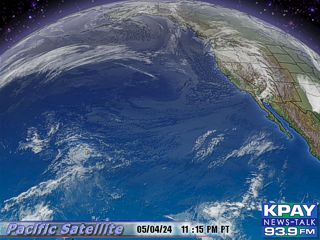
URGENT – WINTER WEATHER MESSAGE
NATIONAL WEATHER SERVICE SACRAMENTO CA
407 PM PDT SAT OCT 23 2010
…POWERFUL PACIFIC STORM TO BRING HEAVY SNOW TO THE HIGHER
ELEVATIONS OF THE SIERRA NEVADA AND LASSEN PARK…
CAZ068-241245-
/O.NEW.KSTO.WS.W.0014.101023T2307Z-101025T0600Z/
WESTERN PLUMAS COUNTY/LASSEN PARK-
407 PM PDT SAT OCT 23 2010
…WINTER STORM WARNING IN EFFECT UNTIL 11 PM PDT SUNDAY ABOVE
7500 FEET…
THE NATIONAL WEATHER SERVICE IN SACRAMENTO HAS ISSUED A WINTER
STORM WARNING ABOVE 7500 FEET FOR HEAVY SNOW…AND BLOWING SNOW
WHICH IS IN EFFECT UNTIL 11 PM PDT SUNDAY FOR WESTERN PLUMAS
COUNTY.
* SNOW ACCUMULATIONS: 6 INCHES TO A FOOT ARE POSSIBLE ABOVE 7500
FEET IN WESTERN PLUMAS COUNTY…WITH SEVERAL FEET OF SNOW
OCCURRING ON TOP OF MOUNT LASSEN.
* ELEVATION: ABOVE 7500 FEET.
* TIMING: SNOW WILL OCCUR OVERNIGHT AND SUNDAY AND WILL BE HEAVY
AT TIMES.
* LOCATIONS INCLUDE: LASSEN NATIONAL PARK.
* WINDS: SOUTHWEST WINDS 20 TO 40 MPH WITH GUSTS TO 70 MPH.
* IMPACTS: PERIODS OF SNOW AND STRONG SOUTHWEST WINDS CAUSING
BLOWING SNOW WILL RESULT IN POOR VISIBILITIES ABOVE 7500 FEET.
ALTHOUGH THE WINTER CAMPGROUND MAY EXPERIENCE RAIN…SNOW WILL
OCCUR ON THE ROAD TO MOUNT LASSEN.
PRECAUTIONARY/PREPAREDNESS ACTIONS…
A WINTER STORM WARNING FOR HEAVY SNOW MEANS SEVERE WINTER WEATHER
CONDITIONS ARE EXPECTED OR OCCURRING.
&&
$$
CAZ069-241245-
/O.NEW.KSTO.WS.W.0014.101024T0600Z-101025T0600Z/
WEST SLOPE NORTHERN SIERRA NEVADA-
407 PM PDT SAT OCT 23 2010
…WINTER STORM WARNING IN EFFECT FROM 11 PM THIS EVENING TO
11 PM PDT SUNDAY ABOVE 7500 FEET FOR THE WEST SLOPE NORTHERN
SIERRA NEVADA…
THE NATIONAL WEATHER SERVICE IN SACRAMENTO HAS ISSUED A WINTER
STORM WARNING ABOVE 7500 FEET FOR HEAVY SNOW AND BLOWING SNOW
…WHICH IS IN EFFECT FROM 11 PM THIS EVENING TO 11 PM PDT SUNDAY
FOR THE WEST SLOPE OF THE NORTHERN SIERRA NEVADA.
* SNOW ACCUMULATIONS: 1 TO 2 FEET OF SNOW ABOVE 7500 FEET.
* ELEVATION: ABOVE 7500 FEET.
* TIMING: RAIN AND SNOW OVER THE SIERRA NEVADA WILL CONTINUE
OVERNIGHT AND BE HEAVY AT TIMES DURING THE DAY ON SUNDAY.
* LOCATIONS INCLUDE: THE HIGHER ELEVATIONS OF THE SIERRA NEVADA
INCLUDING SONORA PASS ON HIGHWAY 108…EBBETS PASS ON HIGHWAY
4…CARSON PASS ON HIGHWAY 88…AND ECHO SUMMIT ON HIGHWAY 50.
* WINDS: SOUTHWEST WINDS 20 TO 40 MPH WITH GUSTS TO 70 MPH.
* IMPACTS: HEAVY SNOW AND STRONG SOUTHWEST WINDS WILL RESULT IN
POOR VISIBILITY…AND POSSIBLE ROAD CLOSURES OR DANGEROUS
TRAVELING CONDITIONS OVER THE HIGHER MOUNTAIN PASSES.
PRECAUTIONARY/PREPAREDNESS
ACTIONS…
A WINTER STORM WARNING FOR HEAVY SNOW MEANS SEVERE WINTER WEATHER
CONDITIONS ARE EXPECTED OR OCCURRING. SIGNIFICANT AMOUNTS OF SNOW
ARE FORECAST THAT WILL MAKE TRAVEL DANGEROUS. ONLY TRAVEL IN AN
EMERGENCY. IF YOU MUST TRAVEL…KEEP AN EXTRA FLASHLIGHT…
FOOD…AND WATER IN YOUR VEHICLE IN CASE OF AN EMERGENCY.
Haiti cholera outbreak growslink
 A man suffering cholera symptoms holds his serum bag as he is treated in Robine, Haiti, on Saturday. A spreading cholera outbreak in rural Haiti threatened to outpace aid groups as they try to keep the disease from reaching the camps of earthquake survivors in Port-au-Prince. (Ramon Espinosa/Associated Press)
An outbreak of cholera is worsening in Haiti, and moving closer to the country's earthquake-devastated capital, Port-au-Prince.
As of the most recent reports on Saturday evening, the disease has killed at least 208 people and sickened another 2,674.
There are concerns tens of thousands of people made homeless by January's earthquake could be at risk.
The outbreak began in the rural Artibonite region, which hosts more than one million quake refugees. Cases have now been confirmed outside of Artibonite, in Arcahaie, a town closer to the capital.
Health officials fear what could happen if the disease spreads to Port-au-Prince, where hundreds of thousands of quake survivors live in tarp camps.
"If the epidemic makes its way to Port-au-Prince, where children and families are living in unsanitary, overcrowded camps, the results could be disastrous," said Dr. Estrella Serrano, World Vision's emergency response health and nutrition manager.
Reuters reported that UN humanitarian spokeswoman Imogen Wall said five cases of cholera have been reported in Port-au-Prince, but she said those people contracted the disease in the Artibonite region before they returned to the capital and became sick.
"They were very quickly diagnosed and isolated," Wall told Reuters. "This is not a new location of infection."
 A boy suffering from cholera sleeps while waiting for medical treatment at a hospital in the Marchand Dessaline zone, about 36 kilometres from the town of Saint Marc, on Friday. (St-Felix Evens/Reuters)
Cholera is a waterborne bacterial infection spread through contaminated water. It causes severe diarrhea and vomiting that can lead to dehydration and death within hours. Treatment involves administering a salt-and-sugar-based rehydration serum.
Red Cross spokeswoman Julie Sell said that beginning Monday teams would begin teaching disease prevention to people living in the refugee camps.
"We are taking this very seriously, but we also want to make sure that every one of our people have the information they need," she said.
Read more:
http://www.cbc.ca/world/story/2010/10/23/haiti-cholera-outbreak.html#ixzz13GgwtUl5GEOMAGNETIC STORM WARNING: NOAA forecasters estimate a 40% chance of severe geomagnetic storms around the poles on Oct. 25th. The forecast is prompted by a possible double whammy: both a solar wind stream and a CME could hit Earth's magnetic field on that date. High-latitude sky watchers should be alert for auroras.
Massive stretches of weathered oil spotted in Gulf of Mexicolink
Just three days after the U.S. Coast Guard admiral in charge of the
BP oil spill cleanup
declared little recoverable surface oil remained in the Gulf of Mexico, Louisiana fishers Friday found miles-long strings of weathered oil floating toward fragile marshes on the
Mississippi River delta.
The discovery, which comes as millions of birds begin moving toward the region in the fall migration, gave ammunition to groups that have insisted the government has overstated clean-up progress, and could force reclosure of
The oil was sighted in West Bay, which covers approximately 35 square miles of open water between Southwest Pass, the main shipping channel of the river, and Tiger Pass near Venice. Boat captains working the BP clean-up effort said they have been reporting large areas of surface oil off the delta for more than a week but have seen little response from BP or the Coast Guard, which is in charge of the clean-up. The captains said most of their sightings have occurred during stretches of calm weather, similar to what the area has experienced most of this week.
On Friday reports included accounts of strips of the heavily weathered orange oil that became a signature image of the spill during the summer. One captain said some strips were as much as 400 feet wide and a mile long.
The captains did not want to be named for fear of losing their clean-up jobs with BP.
Coast Guard officials Friday said a boat had been dispatched to investigate the sightings, but that a report would not be available until Saturday morning.
However, Times-Picayune photojournalist Matt Hinton confirmed the sightings in an over-flight of West Bay.
Robert Barham, secretary of the Louisiana Department of Wildlife and Fisheries, said if the sightings are confirmed by his agency, the area will be reclosed to fishing until it is confirmed oil-free again.
Just Tuesday, Coast Guard Rear Adm. Paul Zukunft, in charge of the federal response, and his top science adviser, Steve Lehmann, said that little of the 210 million gallons of oil spilled into the Gulf remained on the surface or even on the Gulf's floor. Lehmann pointed to extensive tests conducted by the National Oceanic and Atmospheric Administration that included taking samples of water from various depths, as well as collections of bottom sediments both far offshore and close to the coast.
Those claims, announced on the six-month anniversary of the spill, brought quick rebuttals from a variety of environmental and fishermen's groups who insist their members have been reporting sightings of surface oil all along.
LSU environmental sciences professor Ed Overton, who has been involved in oil spill response for 30 years, said he believes both claims could be accurate. The Louisiana sweet crude from the Deepwater Horizon is very light and has almost neutral buoyancy, Overton said, which means that when it picks up any particles from the water column, it will sink to the bottom.
"It's quite possible that when the weather calms and the water temperatures changes, the oil particles that have spread along the bottom will recoagulate, then float to the surface again and form these large mats.
"I say this is a possibility, because I know that the (Coast Guard) has sent boats out to investigate these reports, but by the time they get to the scenes, the weather has changed and they don't see any oil."
"I think the reports are credible, but I also think the incident responders are trying to find the oil, too,'' Overton said. "This is unusual, but nothing about this bloody spill has been normal since the beginning."
Overton said it is important for the state to discover the mechanism that is causing the oil to reappear because even this highly weathered oil poses a serious threat to the coastal ecology.
"If this was tar balls floating around, that would be one thing, but these reports are of mats of weathered oil, and that can cause serious problems if it gets into the marsh," he said
The reports are a great concern to
wildlife officials. The Mississippi delta is a primary wintering ground for hundreds of thousands of ducks and geese, some of which already have begun arriving. The West Bay area leads into several shallower interior bays that attract ducks, geese and myriad species of shore and wading birds each winter.
Earlier this month state wildlife officials were expressing optimism the spill would have minimal impact on most waterfowl visitors because little oil had penetrated the sensitive wintering grounds.
 Enlarge MATTHEW HINTON / THE TIMES-PICAYUNE Oil was spotted in West Bay just west of the Southwest Pass of the Mississippi River, seen at top left, by the Gulf of Mexico Friday October 22, 2010. Oil Slick in West Bay gallery (9 photos)


No comments:
Post a Comment
Note: only a member of this blog may post a comment.