Friday 5 November 2010


Kilauea Lava Enters the Oceanlink

 
Kilauea Lava Enters the Ocean
download large image (1 MB, JPEG) acquired September 28, 2010
Kilauea Lava Enters the Ocean
download large image (130 KB, JPEG) acquired September 30, 2010
The youngest land on Earth lies along the southern coast of the island of Hawaii, where lava from Kilauea Volcano enters the ocean. When lava meets the sea, it vaporizes seawater and creates a dense plume of steam. Over time, the lava builds a delta, extending the shoreline of Hawaii. From November 1986—when lava from the current eruption first reached the ocean—through December 2009, Kilauea created 192.3 hectares (475 acres) of new land.
This natural-color satellite image shows lava entering the ocean at the Puhi-o-Kalaikini Delta. It was acquired by the Advanced Land Imager (ALI) aboard Earth Observing-1 (EO-1) on September 28, 2010. Black areas are fresh lava flows, the earliest of which were laid down from 1986 to 1992. Activity along this section of coast resumed in 2007, with breakouts earlier this year encroaching on the town of Kalapana, which was partially covered in 1990 and 1991. Healthy vegetation is green, while vegetation scorched by recent lava flows is brown. Trade winds blow the white plume to the west. The image is accompanied by an aerial photograph taken on September 30 by the U.S. Geological Survey's Hawaii Volcano Observatory.
  1. References

  2. United States Geological Survey. (2010, October 5). Recent Kilauea Status Reports, Updates, and Information Releases. Accessed October 5, 2010.
  3. United States Geological Survey. (2010, October). Summary of the Pu’u ’ō ’Ō-Kupaianaha Eruption, 1983-present. Accessed October 5, 2010.
NASA Earth Observatory image by Robert Simmon, using ALI data from the NASA EO-1 team. Aerial photograph courtesy USGS Hawaii Volcano Observatory. Caption by Robert Simmon.

This is intresting but would the PTB give messages like this ????? 


Indonesian Volcano eruptions increasinglink

Indonesia Volcano’s Eruptions Stump Scientists
By Lauren Frayer, AOL News

Eruptions from Indonesia’s ferocious Mount Merapi keep getting worse, prompting more villagers to run for their lives and puzzling scientists trying to decipher Mother Nature’s plans.
image
Hot ash clouds are sweeping across central Java, shooting up to six miles into the sky and snarling local air traffic. Today’s booming eruptions have been the strongest since Merapi—whose name means “Mountain of Fire” in Javanese—exploded on Oct. 26, volcanologist Kurniadi Rinekso told Agence France-Presse.
Indonesian officials announced five more deaths from the suffocating lava and smoke, raising Merapi’s total death toll to at least 44, CNN reported. Nearly 75,000 people are huddled in evacuation shelters far from their livelihoods, and it doesn’t look as if they’ll be able to return home anytime soon.

“It looks like we may be entering an even worse stage,” state volcanologist Surono told The Associated Press. After predicting earlier this week that eruptions would ease up, scientists are throwing up their hands as they are confronted today with eruptions three times stronger than expected. “We have no idea what’s happening now,” Surono said.
Merapi’s ash prompted global concern today when a Qantas airliner suffered engine failure after takeoff from Singapore’s airport. The incident occurred several hundred miles away from Merapi, and officials say they’re still investigating, but it appears unlikely that volcanic ash could have affected the plane. The A380 managed an emergency landing back in Singapore, and no one was hurt.
The latest eruptions have also been accompanied by tremors, a sign that energy is still pent up inside the volcano and unable to escape, the head of the Volcanic Technology Development and Research Center, Subandrio, told The Jakarta Post.
“This can [also] be seen from the hot clouds that have been rising from the mountain’s peak,” he said.
Indonesia’s island archipelago sits on the so-called Pacific Ring of Fire, where the world’s most volatile fault lines lie deep under the earth’s crust. Earthquakes and volcanoes are common there along the eastern and western Pacific rims.
See story here.
=======================================
Reports from the Global Volcanism Program:
According to the Darwin VAAC, ground-based reports indicated an eruption from Merapi on 28 October. Cloud cover prevented satellite observations. CVGHM reported that two pyroclastic flows occurred on 30 October. According to a news article, ash fell in Yogyakarta, 30 km SSW, causing low visibility. CVGHM noted four pyroclastic flows the next day.
On 1 November an eruption began mid-morning with a low-frequency earthquake and avalanches. About seven pyroclastic flows occurred during the next few hours, traveling SSE a maximum distance of 4 km. A gas-and-ash plume rose 1.5 km above the crater and drifted E and N. CVGHM recommended that evacuees from several communities within a 10-km radius should continue to stay in shelters or safe areas. The Darwin VAAC reported that a possible eruption on 1 November produced an ash plume that rose to an altitude of 6.1 km (20,000 ft) a.s.l., according to ground-based reports, analyses of satellite imagery, and web camera views. On 2 November an ash plume was seen in satellite imagery drifting 75 km N at an altitude of 6.1 km (20,000 ft) a.s.l. News outlets noted diversions and cancellations of flights in and out of the Solo (40 km E) and Yogyakarta airports. The Alert Level remained at 4 (on a scale of 1-4).
CVGHM reported 26 pyroclastic flows on 2 November. A mid-day report on 3 November stated that 38 pyroclastic flows occurred during the first 12 hours of the day. An observer from the Kaliurang post saw 19 of those 38 flows travel 4 km S. Plumes from the pyroclastic flows rose 1.2 km, although dense fog made visual observations difficult. Ashfall was noted in some nearby areas.
Geologic Summary. Merapi, one of Indonesia’s most active volcanoes, lies in one of the world’s most densely populated areas and dominates the landscape immediately N of the major city of Yogyakarta. The steep-sided modern Merapi edifice, its upper part unvegetated due to frequent eruptive activity, was constructed to the SW of an arcuate scarp cutting the eroded older Batulawang volcano. Pyroclastic flows and lahars accompanying growth and collapse of the steep-sided active summit lava dome have devastated cultivated and inhabited lands on the volcano’s western-to-southern flanks and caused many fatalities during historical time. The volcano is the object of extensive monitoring efforts by the Merapi Volcano Observatory (MVO).


Clouds: The Wild Card of Climate Changelink

I guess they really don’t have a full handle on the science and consensus after all.
NSF Releases Online, Multimedia Package Titled, “Clouds: The Wild Card of Climate Change”

Reader-friendly multimedia package covers the crucial but enigmatic role of clouds on climate change, and how scientists are defining that role
Photo of clouds from an airplane over Michigan.
Clouds from an airplane over Michigan.
Credit and Larger Version
November 4, 2010
View a webcast with David Randall, professor of atmospheric science at Colorado State University.
As discussions about climate change continue, one critical factor about this phenomenon has remained largely unknown to the public: the important but enigmatic role of clouds in climate change. The role of clouds is important because at any given time about 70 percent of the Earth is covered by clouds. The role of clouds is enigmatic because clouds can exert opposing forces: Some types of clouds help cool the Earth and some types of clouds help warm it. Which effect will win out as our climate continues to change? So far, no one is certain.

In order to help clear the air on clouds, the National Science Foundation is releasing an online multimedia package on the role of clouds on climate change, entitled, “Clouds: The Wild Card of Climate Change.” It addresses such pressing questions as, will clouds help speed or slow climate change? Why is cloud behavior so difficult to predict? And how in the world are scientists learning to project the behavior of these ephemeral, ever-changing, high-altitude phenomena?
“Clouds: The Wild Card of Climate Change” features:
  • a live webcast with cloud and climate expert: David Randall, director of the Center for Multiscale Modeling of Atmospheric Processes and a professor of atmospheric science at Colorado State University;
  • informative, easy-to-understand texts;
  • eye-catching photos;
  • a narrated slide show;
  • dynamic animations;
  • enlightening interviews with cloud researchers; and
  • downloadable documents.
This package–which provides a wealth of information to reporters, policymakers, scientists, educators, the public and students of all levels–is posted on NSF’s website.
 

Magnetic Portals Connect Earth to Sunlink
                      

      Artist's concept of magnetic "cord"
      See larger image here.    
30 Oct 08 - "During the time it takes you to read this article," says this story from NASA, "something will happen high overhead that until recently many scientists didn't believe in. A magnetic portal will open, linking Earth to the sun 93 million miles away. Tons of high-energy particles may flow through the opening before it closes again, around the time you reach the end of the page.
"It's called a flux transfer event or 'FTE,'" says space physicist David Sibeck of the Goddard Space Flight Center. "Ten years ago I was pretty sure they didn't exist, but now the evidence is incontrovertible."
"FTEs are not just common, but possibly twice as common as anyone had ever imagined, says Sibeck.
"Researchers have long known that the Earth and sun must be connected. Earth's magnetosphere (the magnetic bubble that surrounds our planet) is filled with particles from the sun that arrive via the solar wind and penetrate the planet's magnetic defenses. They enter by following magnetic field lines that can be traced from terra firma all the way back to the sun's atmosphere.
"The connections are not steady,” says Sibeck. “They are often brief, bursty and very dynamic."
"How FTEs form: On the dayside of Earth (side closest to the sun), Earth's magnetic field presses against the sun's magnetic field. Approximately every eight minutes, the two fields briefly merge or "reconnect," forming a portal through which particles can flow. The portal takes the form of a magnetic cylinder about as wide as Earth.
Did you catch that? "About as wide as Earth." The artist's concept above shows something far smaller than that. I'm thinking that a magnetic reversal on Earth could wreak havoc with these magnetic portals.


Goodbye Global Warming, Hello Biodiversity

By Alan Carubalink
 
                       page delimiter


30 Oct 10 - After three decades of trying to push the global warming scam to a point where billions could be made selling and trading bogus “carbon credits”, the global schemers have abandoned it in the wake of 2009 revelations that a handful of rogue climate scientists were literally inventing the data to support it.

If there is one lesson to be learned from and about environmentalists, it is that they are utterly relentless. The ultimate goal is one-world government directed from the United Nations by unelected bureaucrats who are soulless strangers to the truth, to morality, to humanity.

The United States supports this abomination to the tune of billions every year.

The United Nations is a place where some of the world’s dictatorships have delegates representing them on its Human Rights Council, where a vast Oil-for-Food scandal flourished while Saddam Hussein held power in Iraq, where a single agency’s sole purpose is to ensure that Palestinians remain refugees six decades after the rebirth of Israel.

It is an organization where all manner of international treaties are ginned up to extend its control over the entire land mass and all the waters of the earth.

It is where the Intergovernmental Panel on Climate Change (IPCC) practiced its deceit, regularly documenting a rise in the earth’s average temperature even when a new natural cooling cycle began in 1998.

Everything that could be attributed to a phony global warming to keep the people of the world scared flowed from this enormous lie. It caused governments to invest billions into the worst forms of energy, wind and solar, along with endless other equally worthless “Green” programs.

So, now, permit me to introduce you to the NEXT Big Lie—biodiversity!

It is the claim that a “Global extinction crisis looms, new study says.” That’s the headline on an October 27 Washington Post article by Juliet Eilperin, the Post’s designated shameless scaremongering reporter.

In June, the delegates from 200 nations gathered in Busan, a South Korean port city, under the banner of the Intergovernmental Science Policy Platform on Biodiversity and Ecosystem Services (IPBES), a platform just like the discredited IPCC, but with the goal of denying vast areas of the earth from the development needed to feed six billion people and provide the raw materials vital to the energy required for a modern technological society dependent on electricity and on transportation fuels.

The “reason” for this is the alleged extinction of “nearly 26,000 species across the globe.” The list was compiled by the International Union for Conservation of Nature that purports to count all the mammals, birds, amphibians, reptiles, and fish in the world to determine how “imperiled” there.

The very idea evokes incredulity. It is laughable and it is impossible. In the same fashion people were told that the global warmers could predict the temperature of the Earth fifty to a hundred years from now, we are expected to believe that all current species are imperiled. Just as humans were blamed for a non-existent rise in the Earth’s temperature, human are blamed on a massive and fictional extinction.

Consider that, from the earliest forms of life on earth to the existence of present species all have been engaged daily in the act of killing and eating one another. Ruminants that dine on grasses and other vegetation remain the prey for predator species.

Consider that of all the species that ever existed on Earth, 99% are extinct.

Nicholas K. Dulvy, a co-author of the list of alleged endangered species, complained that “We’ve transformed a third of the habitable land on earth for food production.” Oh, heaven forbid that humans should have enough food!

So, naturally, as reporter Eilperin noted, “Environmental groups are pushing for a goal of protecting 25 percent of all land on earth and 15 percent of the sea by 2020” even though, under the UN Convention on Biological Diversity, roughly 14 percent of terrestrial areas and less than one percent of the ocean are already subject to so-called “environmental safeguards.”

Expect to begin hearing from yet a new group of “scientists” claiming that every creature from antelopes to zebras, from anteaters to weasels, albatrosses to vultures, crocodiles to vipers, and all the fish in the seas are doomed! Doomed! Doomed!

Billions of dollars that should go to feeding the hungry, caring for the sick, and all manner of humanitarian needs will be siphoned off by this new group of United Nations grifters and charlatans for endless “research” grants and, of course, more international meetings to discuss this horrible new crisis.

This is how the cruel enviro-mafia works. We have all had a taste of it since the late 1980s when the global warming hoax was first perpetrated. The biodiversity lie needs a quicker death.

Indonesian volcano erupts, kills dozenslink

Danger zone expanded after eruption

Indonesian soldiers and rescuers run after an eruption of Mount Merapi in Argomulyo, Yogyakarta, Indonesia, on Friday. Indonesian soldiers and rescuers run after an eruption of Mount Merapi in Argomulyo, Yogyakarta, Indonesia, on Friday. (Trisnadi/Associated Press) Blistering gas from Indonesia's most volatile volcano spewed farther than expected Friday, incinerating houses at the edge of the danger zone, triggering chaotic evacuations and pushing the death toll above the 100 mark.
Soldiers joined overnight rescue operations in Bronggang, 15 kilometres from the mouth of the crater, pulling corpses from smoldering homes and streets blanketed by ash five centimetres deep, then piling them into the backs of trucks.
Dozens of injured — with clothes, blankets and even mattresses fused to their skin by the gas clouds — were carried away on stretchers.
"We're totally overwhelmed here!" said Heru Nogroho, a spokesman at the Sardjito hospital, as the number of bodies dropped off at their morgue climbed to 58 — making it the deadliest day Mount Merapi has seen in nearly 80 years — bringing the overall toll to 102.
Villager Niti Raharjo, 47, was in the hospital with burn wounds to his legs, alongside his 19-year-old son who suffered burns to his shoulder, hands and legs. Raharjo said a strong tremor woke him up and he grabbed his motorbike and the pair rode away.
"The heat surrounded us and there was white smoke everywhere," he said. "I saw people running, screaming in the dark, women so scared they fell unconscious. Everything was in turmoil while an explosion that sounded like it was from a war came along the river ... then it got worse as ash and debris rained down.
Villagers carrying their belongings arrive at a temporary shelter at Maguwoharjo Stadium in Yogyakarta, Indonesia, on Friday. Villagers carrying their belongings arrive at a temporary shelter at Maguwoharjo Stadium in Yogyakarta, Indonesia, on Friday. (Beawiharta/Reuters) When the debris filled the road, they were thrown from the motorbike. "But fear made us get up and get out of the hell, regardless of the burning pain in our feet," he said.
Merapi's booming explosion just after midnight was six times as powerful as its initial blast on Oct. 26 and triggered a panicked evacuation. Men with ash-covered faces streamed down the scorched slopes on motorcycles, followed by truckloads of women and children, many crying.
Officials wearing facemasks barked out orders on bullhorns as rocks and debris rained from the sky.
Up until Friday, the village of Bronggang, home to about 80 families, was considered to be within the safety zone, despite signs that the notoriously unpredictable mountain could be ready to blow.
Mount Merapi, which means "Fire Mountain," has erupted many times in the last century. In 1994, over a period of several days, 60 people were killed, while in 1930, more than a dozen villages were torched, leaving up to 1,300 dead.
The greatest danger is always pyroclastic flows, like those that roared down the southern slopes just before midnight Friday at speeds of up to 100 kilometres per hour.
With many bodies found in front of houses or littering streets it appeared that many of the villagers died from the searing gas while trying to flee, said Col. Tjiptono, a deputy police chief.
Activity at the mountain forced an airport in nearby Yogyakarta to close Friday because runways were covered in heavy white ash. It was not clear when it would reopen, said Agus Andriyanto, who oversees operations.

Danger zone expanded

Mount Merapi's "danger zone," meanwhile, was extended by five kilometres to 20 kilometres from the crater's smoldering mouth after the new eruption, said Subandrio, a state vulcanologist.
(CBC) Even scientists from Merapi's monitoring station were told they had to pack up and move down the mountain. They were scrambling to repair four of their five seismographs destroyed by the heavy soot showers.
Despite earlier predictions that dozens of big explosions that followed Merapi's initial Oct. 26 blast would ease pressure building up behind a magma dome, eruptions have been intensifying, baffling experts who have long monitored Merapi.
"I don't want to speculate if there's going to be a bigger eruption," said Syamsu Rizal, a state expert on volcanoes. "But there's no indication at [this] stage that we're going to see it see quiet down at all in the near future."
More than 75,000 people living along Merapi's fertile slopes have been evacuated to crowded emergency shelters, many by force, in the last week. Some return to their villages during lulls in activity, however, to tend to their livestock.
Before Friday, the death toll from Merapi stood at 44, with most of the victims in the Oct. 26 blast.
Indonesia, a vast archipelago of 235 million people, is prone to earthquakes and volcanos because it sits along the Pacific "Ring of Fire," a horseshoe-shaped string of faults that line the Pacific Ocean.
The volcano's initial blast occurred less than 24 hours after a towering tsunami slammed into the remote Mentawai islands on the western end of the country, sweeping entire villages to sea and killing at least 428 people.
The tsunami left thousands of people displaced, with many living in government camps.


Read more: http://www.cbc.ca/world/story/2010/11/05/indonesia-mount-merapi-blast.html#ixzz14POdg9eB


Flood waning, Iceland volcano eruption less likelylink

REYKJAVIK, Iceland -- Scientists say glacial flooding from Iceland's most active volcano has peaked, with no sign yet of an eruption.

Geophysicists have been monitoring the Grimsvotn volcano since melted glacial ice began pouring from it several days ago, signaling a possible eruption.
Icelandic Meteorological Office scientist Gunnar Gudmundsson said Thursday that floodwaters are receding, and tremors at the volcano are also decreasing.
He says it is now “less likely that we will get an eruption, at least in the near future.”
Grimsvotn lies under the uninhabited Vatnajokull glacier in southeast Iceland.

China and Germany express concern over US Fed movelink

US dollar bills The US central bank hopes that the move could boost the US economy's recovery
Germany and China have expressed concerns over US plans to pump $600bn (£373bn) into the US economy.
German Finance Minister Wolfgang Schaeuble said the US would not solve its problems, but create "extra problems for the world" instead.
Some countries fear that the US Federal Reserve's move could hurt their exports by making their currencies stronger.
China's Central Bank head Zhou Xiaochuan urged to look into "reforming the international currency system".
He did not elaborate how the system should be changed.
The US central bank announced on Wednesday that it would spend $600bn to buy government bonds, in the hope that the cash injection can kickstart the country's economy.
However, this weakens the dollar, boosting US exports while making imports more expensive.
'Clueless' "If the domestic policy is optimal policy for the United States alone, but at the same time it is not an optimal policy for he world, it may bring a lot of negative impact to the world," said Mr Zhou.
It is not that the Americans have not pumped enough liquidity into the market and now to say let's pump more into the market is not going to solve their problems”
End Quote Wolfgang Schaeuble German finance minister
"There is a spill over."
China's Vice Foreign Minister Cui Tiankai said the Federal Reserve had the right to take steps without consulting other countries beforehand, but added: "They owe us some explanation."
Germany's finance minister Wolfgang Schaeuble said on German television that "with all due respect, US policy is clueless."
"It is not that the Americans have not pumped enough liquidity into the market and now to say let's pump more into the market is not going to solve their problems."
He added that the German government was going to hold bilateral talks with US officials and also discuss the topic at the G20 summit in Seoul next week.
The latest move by the Fed has been dubbed QE2 as it follows the central bank's decision to pump $1.75tn into the economy during the downturn in its first round of quantitative easing.


Costa Rica landslide kills at least 20 as storm hitslink

Volunteers search for landslide victims in the San Antonio de Escazu district Parts of Costa Rica have seen three times the average rainfall for the whole of November in just a few days
A landslide in Costa Rica caused by heavy rain has killed at least 20 people in a suburb of the capital, San Jose, officials say.
A number of people are still missing following the landslide in the western district of San Antonio de Escazu.
A hillside gave way, sending tons of rock and earth onto the houses below.
The Costa Rican government is considering declaring a national emergency.
Rescuers were searching for survivors in the district, where poor people live in shanty dwellings alongside much more upmarket homes.
The area is popular with hikers and rock climbers.
Exceptional rain President Laura Chinchilla requested help from neighbouring countries to reach remote areas of the country that have been flooded by the storm.
She said the downpour was likely to continue into Friday.
"The important thing now is to be thinking of the victims' families," she told a news conference.
Hundreds of people in the capital and along the Pacific coast have been moved to temporary accommodation because of the flooding.
National Emergency Commission President Vanessa Rosales said the rains may have had damaged several major coffee-growing areas in Costa Rica's highlands.
The National Meteorological Institute said that since Tuesday the equivalent of three times the average rainfall for the whole of November had been recorded in the Pacific area.

Haiti quake victims told to flee approaching hurricanelink


Click to play
Refugees living in camps in Port-au-Prince are being urged to leave
A tropical storm has regained hurricane strength as it powers towards Haiti, threatening earthquake survivors.
Hurricane Tomas is packing winds of 80mph (130 kph) and is expected to gain in strength as it moves north-east.
The US National Hurricane Centre says the centre of the hurricane will pass near western Haiti later on Friday.
The government has urged tens of thousands of people living in tented homes to find better shelter, but most say they have nowhere to go.
Forecasters are warning of the danger of flooding and mudslides. Health workers fear heavy rain will exacerbate Haiti's cholera epidemic.
'Protect your lives' Aid agencies are rushing to get emergency shelters ready before Tomas, which has already killed 14 people in Saint Lucia, arrives.
According to the US National Hurricane Centre, Tomas should intensify over the next 24 hours and then lose strength by the end of the weekend.
My sisters and brothers, leave the zones that are at risk, I beg of you”
End Quote Jean-Max Bellerive Haiti prime minister
"The most significant threat from this tropical cyclone should continue to be heavy rainfall which could produce flash flooding and life-threatening mudslides over portions of Haiti and the Dominican Republic during the next couple of days," it said in a bulletin early on Friday.
It has been raining heavily in Haiti for hours, and forecasters warn Hurricane Tomas could destroy many of the makeshift tented homes where 1.3m people have been living since an earthquake in January.
Haiti's leaders have been calling for mass evacuations from the tent cities.
"My sisters and brothers, leave the zones that are at risk, I beg of you," Prime Minister Jean-Max Bellerive urged in a television address.
Quake survivors strengthen shelters as storm nears Those staying in the camps are making their shelters as strong as possible
"There will be rain and wind throughout the country. Don't be stubborn. Leave if you are in a fragile shelter."
President Preval had earlier pleaded with people to "protect" their lives. But he acknowledged that the authorities did not "have enough places [on buses] to move everyone".
The BBC's Laura Trevelyan in the capital, Port-au-Prince, says few refugees have heeded the government warning, although mothers and babies have been evacuated from an exposed camp near the mountains.
"We haven't taken precautions. We are in God's hands," one woman, Ave Lise Mesila, told Reuters news agency from her tent.
Stefano Zannini, Medecins Sans Frontieres' head of mission in Haiti, described the situation as "precarious".
"It is the third big problem people here have had to deal with this year," he told the BBC.
Fear and confusion The NHC has warned of hurricane conditions - winds of 119km/h (74mph) or greater - for Haiti, the south-eastern Bahamas, the Caicos Islands and the Cuban province of Guantanamo.
It also issued a tropical storm warning for Jamaica and the Cuban provinces of Santiago de Cuba and Holguin.
Many earthquake survivors worried that the authorities were trying to permanently move them out.
"We are upset because they have not told us where we are going," Domarcand Fenel, the head of a committee of camp residents, told Reuters. "People believe they want to expel us."
Doctors have warned that torrential rain could flood sanitary installations and contaminate drinking water, worsening a cholera epidemic in the country.
On Wednesday health officials said there had been a 40% jump in the number of new cholera cases and the death toll was 442, with 105 more deaths since Saturday.

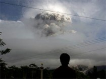
Dozens die in new Mount Merapi eruption in Indonesialink


Click to play
Victims treated for burns as ash cloud covers villages
At least 64 people have been killed in the latest eruption of Indonesia's Mount Merapi volcano - more than doubling the death toll since it became active again last week.
Dozens are being treated for burns and respiratory problems after a gas cloud hit villages with even greater force than the previous eruptions.
More than 100 people are now said to have been killed.
An estimated 75,000 residents have been evacuated from the area.
Mount Merapi, one of the world's most active volcanoes, is located in a densely populated area in central Java.
The latest eruption began late on Thursday, sending residents streaming down the mountain with ash-covered faces.
We're totally overwhelmed here”
End Quote Heru Nugroho Hospital spokesman
Rescue workers said villages in the area were in flames.
Indonesian President Susilo Bambang Yudhoyono has announced that the government will buy all the cattle from farmers in the affected villages to keep people from going back to their homes during the crisis.
He is expected to visit the area later today.
'Danger zone'
Many of the dead are believed to be children from Argomulyo village, 18km (11 miles) from the crater.
Local hospital spokesman Heru Nugroho said 54 bodies had been brought in on Friday. More than 66 others were injured, many of them critically with burns.
Villagers flee their home following another eruption Mount Merapi Victims were covered in hot ash following the latest Merapi eruption
"We're totally overwhelmed here," he told the Associated Press news agency.
Rescuer Utha told AFP news agency: "I found three bodies - a child, mother and father, still on their bed. They must have been sleeping when the hot ash struck their house... We also found a dead man with a phone still on his hand."
Volcanologists Surono told AFP: "This is the biggest eruption so far. The heatclouds went down the slopes as far as 13km (eight miles) and the explosion was heard as far as 20 kilometres away."
The authorities have decided to widen the "danger zone" around the crater from 15 km (9 miles) to 20km (12 miles).
A rescue official told the BBC some of the casualties could have been avoided if residents had stayed away from the danger zone.
Scientists are warning of further eruptions in the coming weeks.
Indonesia is also dealing with the aftermath of another natural disaster, after a tsunami hit the Mentawai islands last week, claiming more than 400 lives and sending thousands into emergency shelters.

No comments:

Post a Comment

Note: only a member of this blog may post a comment.