10 Sep 10 - The Pacific Ocean has been in its warm cycle since the late 1970s, says meteorologist Joe Bastardi. But we're now switching back to the cold phase and a major La Nina. The Pacific Decadal Oscillation (PDO) is the major driver of global climate, says Bastardi, and the winters ahead are going to be brutal.Back in 1998 we had a super El Niño, which brought on - by satellite standards - the warmest year on record. Then came the nasty winter of 01-02.This time will be different, says Bastardi. The wild card is that we were at a peak of solar activity at that time, whereas now solar activity is "feeble at best." "Yeah, sunspots are more than they than they were last year," says Bastardi. "But the overall number of sunspots is down. And if we were measuring it the way we were in the 1800s, it wouldn't be near as high as it is now. Now we have this revisionist way of doing things." Major La Nina Now we’re headed into a major La Nina that’s going to last for the next couple of years. When we come out of that, there’s really good reason to believe the winter of 2012-13, and perhaps beyond, is going to be quite cold. Then there are the wild cards such as Arctic volcanoes, says Joe, and the fact that the current La Nina has come on faster and harder than anything he can remember. Arctic summer temps colder than normal linkBelow corresponding daily average temperatures over the past half century |
10 Sep 10 - According to the Centre for Ocean and Ice at the Danish Meteorological Institute (DMI), during almost this entire summer (June to August period), mean daily temperatures in the Arctic remained below the corresponding daily temperatures over the past half century.
 |
| Daily mean temperature and climate north of the 80th northern parallel. Red line represents this year’s temperatures. Green line represents record since 1958. |
Of even greater significance is the graph’s blue line (the horizontal line) indicating the freezing point of water, says author Lawrence Solomon. When the red line appears above the blue line, temperatures are above 0 degrees and ice will melt. "With temperatures in September now plummeting," says Solomon, "2010 is unlikely to log any more melt days, and the Summer of 2010 will go down in the history books as yet another year in which the Arctic did not melt."
2010 running hot and cold in the USA
Hot summer after a cold winterJoe D’Aleo, ICECAP
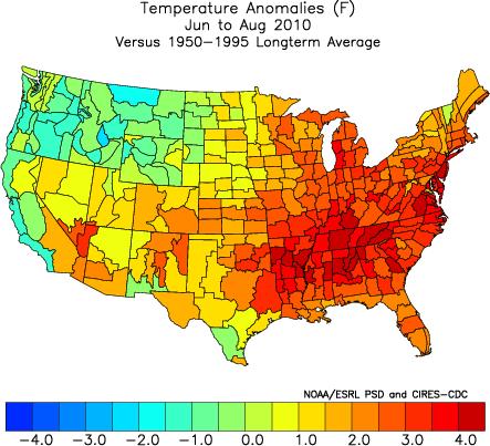
Washington DC and many cities of the east and south had a warm to record warm summer (while parts of the west had a cold to record cold) with the average for the nation the 4th warmest on record. For Washington, it broke many of the records set in 1980 and 1988. It tied with the number of 90F days set in 1988 and fell just 12 days short of the number of 90F days for the year (a few additional still possible) set in 1980.
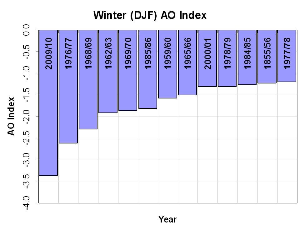
A hot summer is very typical when a strong La Nina follows a strong El Nino winter (1999, 1988, 1966) or when record strong arctic blocking in winter fades (1977). This past winter we saw a record for negative Arctic Oscillation (AO) beating out 1976/77 and 1965/66
The summer was 2.2F above normal for the nation, ranking it as fourth warmest. See map:
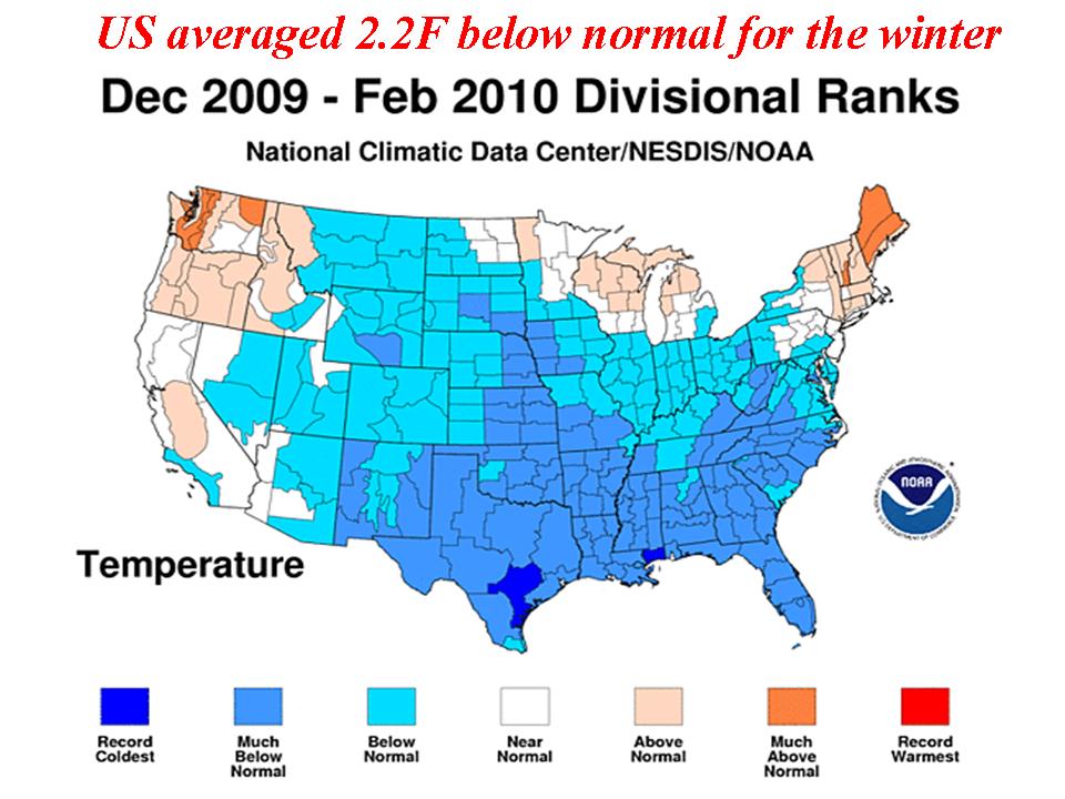
That matches how much last winter the US averaged below normal (2.2F). Last winter was coldest in the south and southeast (in a few spots, coldest ever). Colder to the south of DC but recall DC and surroundings had a record seasonal snowfall.
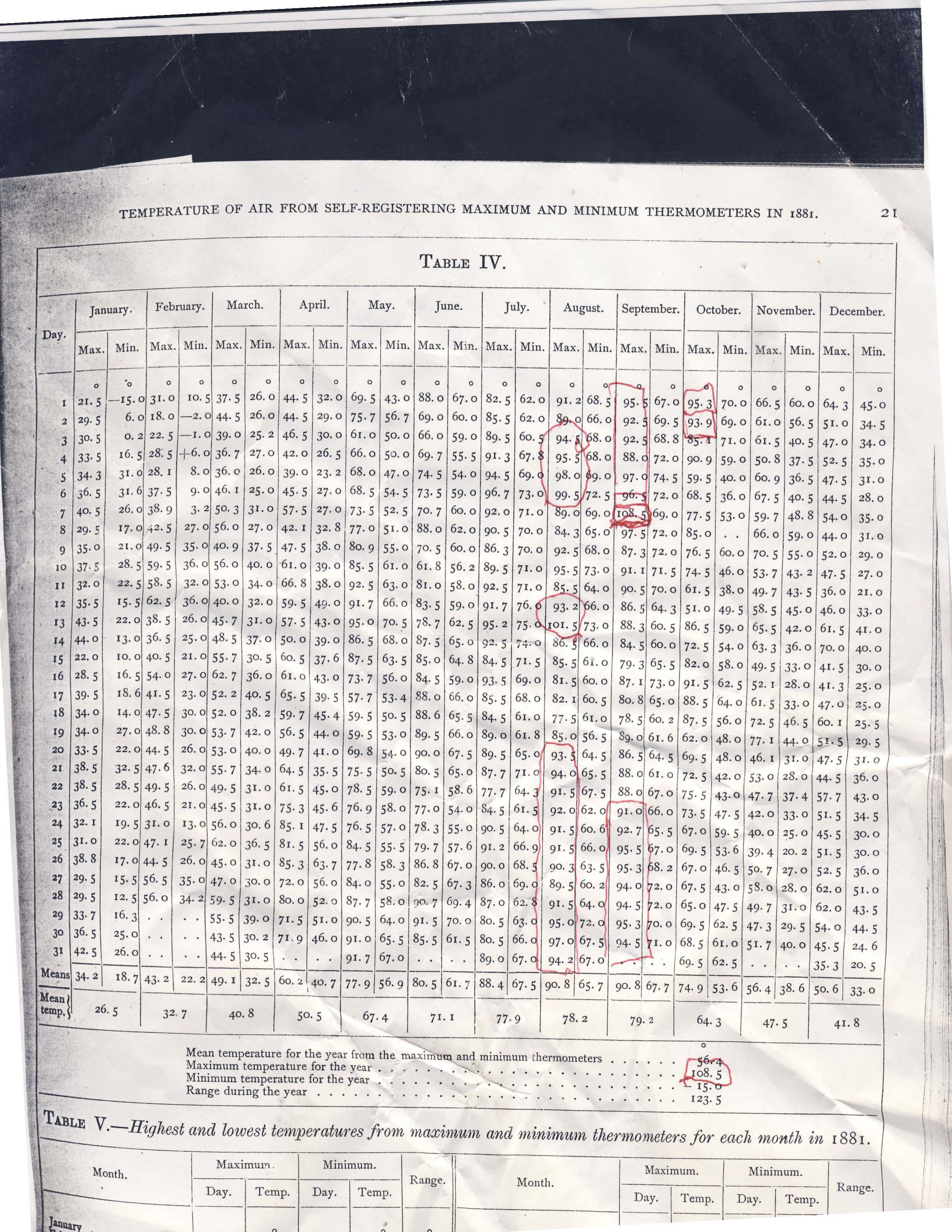
Besides 1980, 1988, other hot summers included 1881, where this record from “Andy” out of the Naval Observatory shows an amazing summer following a very cold January/winter. He writes:
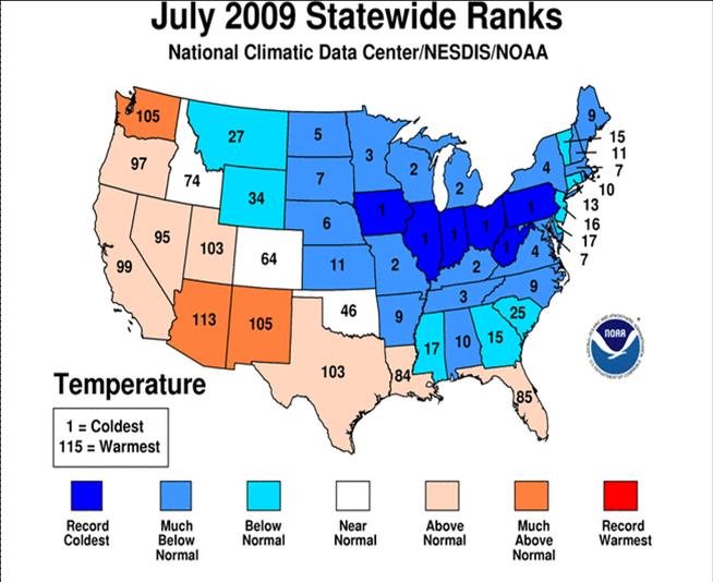
I am attaching a rather rare document, Washington DC weather records for the year 1881 taken at the Naval Observatory.The summer this year was characterized by hot days with high humidities and thus very warm nights. Nighttime lows were especially above the normal. Ironically many of the same areas with warmth this summer had very cool summers the last two years with a record/near record cold July in 2009.
I have highlighted an incredible late summer, early autumn heat wave that got started on August 20th and did not really end until October 4th. There has never been anything remotely approaching the intensity and duration of this heat wave for so late in the year in modern times.
An unbelievable temperature of 108.5 was recorded on the very late date of September 7th! Also the average September average high temperature of 90.8 dwarfs anything you can find in recent years. One could argue that the site or thermometer might reflect a warm bias. Examining the data, June was actually quite cool and July was about average. And back then, no one was pushing an agenda!
That was consistent with a summer after a La Nina winter, one with low solar and high latitude volcanic activity. Last summer and last winter we were told that was weather not climate. This makes any claims that a hot summer this year is indicative of a warming world disingenuous. With La Nina coming on, look for a cool summer again next year. With a negative PDO look for colder years ahead. This will accelerate when the Atlantic cools. The active hurricane season will remove some of the heat built up in the Atlantic by the El Nino suppressed activity last year and reduced winds (mixing) and increased sunshine with a suppressed jet stream, weakened suppressed subtropical high pressure due to record blocking this past winter.
New York battered by twin tornadoes

The fierce storm caused widespread destruction across New York City
More than 1,000 trees were uprooted and power was cut to hundreds of homes when the storm struck on Thursday.
The woman who died was in a car hit by a falling tree and had just switched seats with her husband, who survived.
It was the ninth time New York City has been hit by a tornado since 1950, and the second this year, officials said.
The US National Weather Service said on Friday that the tornadoes had been part of a fast-moving storm, along with a fierce microburst with speeds up to 125mph (200 km/h).
The storm travelled from Staten Island, across New York harbour and then carved a 14-mile (22km) path of destruction from Brooklyn to the Bayside neighbourhood in Queens.
‘Poltergeist’
Parks Commissioner Adrian Benepe said many more trees were so badly damaged they would have to be felled.
The woman who died was named as Aline Levakis, 30, who had been sitting in a parked car in Queens with husband Billy Levakis.
The couple, from Pennsylvania, had just switched seats when the tree fell on them, said their former business partner, Peter Markos.
Mayor Michael Bloomberg described the incident as “tragic”, adding that there had been other stories of lucky escapes from falling trees across the city.
Resident Steve Carlisle, 54, described how he saw a 25ft tree branch fly up the street and then start spinning in the air.
“It was like a poltergeist,” he said.
“Then all the garbage cans went up in the air and this spinning tree hits one of them like it was a bat on a ball.”
New York City has suffered freak storms before. One in August last year toppled about 500 trees in Central Park, the New York Times reported.
No comments:
Post a Comment
Note: only a member of this blog may post a comment.